Browse through selected images taken from Muslim Heritage articles related to Geography...
“Everywhere’s been where it is ever since it was first put there. It’s called geography.” ― Terry Pratchett, Wyrd Sisters
…
Google honors Al-Biruni’s Birthday with this Doodle
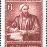
USSR stamp, Abū Rayhān al-Bīrūnī, 6 copecks, 1973
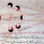
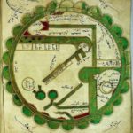
An illustration from al-Biruni’s astronomical works, explains the different phases of the moon
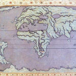
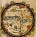
The Tabula Rogeriana, by Al-Idrisi in 1154, is one of the most detailed maps of the ancient world. This map has been rotated to show its similarity with modern maps
South Caucasus (Armenia)
Matrakci’s Tebriz
Granada/Spain and its surrounding areas
Piri Reis’ depiction of the Mediteranean
Al-Qazwini’s world map of the inhabited world, from cosmography
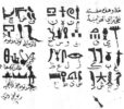
World map from Mahmud el-Kashgari’s Diwan, 11th century
Indian Ocean
Sicily
Mediterranean Sea
Erzurumlu Ibrahim Hakki’s World Map in his Marifetname book
Cyprus
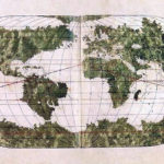
Piri Reis’s World map, 16th century
Tarih-i Hind-i Garbi map, 16th Century
Ali Macar’s world map
City of Istanbul and Develi illumination from Matrakçi’s Beyân-i Menâzil-i Sefer-i ‘Irakeyn
Czech National Library copy of al-Wardi’s map
a copy of al-Wardi’s world map
A copy of Ibn al-Wardi’s world map
16th century copy of Al-Qazwini’s world map from his “Marvels of Regions”
Al-Idrisi’s 12th century world map
World map from the Book of Curiosities manuscript held at the Bodley Library
Persian Gulf’s coast
A world map by Abu Ishaq Ibrahim ibn Muhammad al-Farisi al-Istakhri (934 CE) aka Estakhri. The map is oriented with South at the top, a common feature of maps at the time. Picture displayed on “Old Manuscripts and Maps from Khorasan”
A map by Abu Zaid Ahmed ibn Sahl al-Balkhi (850-934), a Persian geographer who was a disciple of al-Kindi and also the founder of the “Balkhī school” of terrestrial mapping in Baghdad. Picture displayed on “Old Manuscripts and Maps from Khorasan”
Turkish Stamp
A portrait of Marco Polo wearing a Tatar outfit
Mahmud of Kashgar’s map of world (Divânu Lügati’t-Türk, translated into Turkish by Rifat Bilge, Istanbul 1917, 3 vols
Imaginary potrait of Mahmud of Kashgar/Mähmut Qäşqäri
Introduction page from Divânu Lügati’t-Türk
Coordinates of Piri Reis map
Portrait of Pîrî Reis
A Turkey Republic bank note contains Pîrî Reis’ map
This website uses cookies to improve your experience. We'll assume you're ok with this, but you can opt-out if you wish. Cookie settingsACCEPT
Privacy & Cookies Policy
Privacy Overview
This website uses cookies to improve your experience while you navigate through the website. Out of these cookies, the cookies that are categorized as necessary are stored on your browser as they are as essential for the working of basic functionalities of the website. We also use third-party cookies that help us analyze and understand how you use this website. These cookies will be stored in your browser only with your consent. You also have the option to opt-out of these cookies. But opting out of some of these cookies may have an effect on your browsing experience.
Necessary cookies are absolutely essential for the website to function properly. This category only includes cookies that ensures basic functionalities and security features of the website. These cookies do not store any personal information.