A study of historical maps and sea charts indicates that cartographers have often considered map making as an art as well as a science and aimed to record the different parts of the world not only with their topographical details but also with their history.
This short article is taken from the full article (by Professor Gunsel Renda) which is available here as a 7 page PDF file.
 |
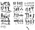
| Figure 1. Chios island (in Aegean Sea) map, Kitab-i Bahriye, Suleymaniye Library, Ayasofya, 2612. |
Researchers of cartography are often geographers or cartographers themselves who examine maps for their content in view of the science of map making, while the illustrations on the maps are often overlooked. A study of historical maps and sea charts indicates, however, that cartographers have often considered map making as an art as well as a science and aimed to record the different parts of the world not only with their topographical details but also with their history. Therefore, city views, costumes, ships, flora and fauna and even portraits found on certain maps have brought them close to being works of art.
Certain illustrated maps have survived from the Roman and Medieval times but it is in the sixteenth and seventeenth centuries that a great number of maps and sea charts or portolans have been produced. It is the real explosion of geography in the sixteenth century that led to the production of maps and sea charts by the Italians, Catalan and Portuguese as well as the Ottomans. This was the natural outcome of the Portuguese expeditions that led to new trade routes and naval traffic especially on the Mediterranean. To this must be added the conflicts that arose in the sixteenth century between the ruling powers in the Mediterranean. Maps and sea charts were needed to provide current knowledge of geography and navigation. Maps and sea charts normally served to guide soldiers for military expeditions and especially mariners who sailed close to the shore as a refuge from corsairs to the ports where they stopped for supply. Suitable harbours or towns were indicated with inscriptions and sometimes with sketchy vignettes. Maps and sea charts have more or less followed the same techniques over the centuries. Portolans or sea charts drawn on vellum are either single sheets, the size of the animal skin used, or they are in the form of atlases made up of separate sheets. They have interconnecting rhumb lines; representing the 32 points of the compass, 32 winds main half and quarter which join in wind roses which are multicoloured and decorated with a variety of motifs. Coast lines are drawn in green or blue, the islands painted in different colours. They also have decorative scale bars ; the place names or legends are written at right angles to the shore in black or red. Some of these maps or sea charts were produced in Italian, Catalan or Ottoman workshops as special presentation copies prepared for rulers or wealthy customers. Important cities which in the simple maps were no more than vignettes developed in these copies into plan views or ground level panoramas of certain cities and harbours with added legends concerning historical facts often indicating the political allegiance of a place. Venice and Genoa were the most frequently illustrated ports although other cities such as Marseilles, Jerusalem, Alexandria or Cairo were represented. They also included figures of rulers or other humans worthy of attention, animals, birds, flags, etc. It is in these illustrated maps that the links between map and picture making bring aesthetic concerns and their artistic component needs to be explored.
 |
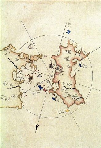
| Figure 2. Canakkale area, Kitab-i Bahriye, Suleymaniye Library, Ayasofya, 2612. |
A study of such maps or sea charts from the Mediterranean reveals the interplay between the diverse cultures in the area and especially the political and cultural relations between the Mediterranean countries, and the different approaches revealed by the works of Italian, Catalan or Ottoman cartographers.
The Catalan or Italian cartographers preparing maps and sea charts for their patrons seem to have developed a special interest towards the Moslem rule in the eastern Mediterranean. Ottoman expansion into Anatolia and especially the conquest of Istanbul in 1453 must have been an unpleasant reality for Italian and Catalan cartographers as they were reluctant to depict the city under Moslem rule and they preferred to indicate if all, the new masters of the Byzantine capital only by a flag and symbolize the Moslem rule in Anatolia by banners with crescents or sometimes a turbaned figure holding a dagger.
The sixteenth century saw the production of several maps and sea charts by the Ottomans. The Ottoman expansion policy in the Mediterranean resulted in the annexation of Syria and Egypt followed by the siege of Rhodes already signalling Ottoman supremacy in the Aegean by 1520’s. This continuing interest in campaigns in the Mediterranean necessitated the presence of a powerful fleet and extensive geographic material. It was Mehmed II in the 15th century who had acquired a rich collection of geographical sources for the Ottoman court. His personal interest in geography is revealed by a large number of books and maps still kept in the Topkapi Palace Museum. Francesco Berlinghieri, the Florentine geographer, dedicated a copy of Ptolemy’s Geographike’s Italian translation to Mehmed II. A military map of the Venetian republic also commissioned by Mehmed II is now in the Topkapi Museum.
Various military maps or siege plans were produced by the Ottomans. In two siege plans, one of Belgrade and the other of Lepanto, painted in the technique of miniature painting, Lepanto is shown enclosed in flatly rendered walls but the monuments themselves in elevation. It is in a way a map and also a miniature painting. The plan of Belgrade has scattered vignettes reminiscent of portolan style but the way the buildings are shown, the plants rendered and the colouring is typical of Ottoman miniatures of the time. The best examples of Ottoman mapping are found among the works of Piri Reis, a mariner and a cartographer at the court of Selim I and Suleyman the Magnificent. His well-known world map of 1513 based on the Columbus map of 1498 and the various copies of his Kitab-i Bahriye, a book of portolans and sailing directions, are full of city views and legendary images worthy of attention. In the long inscription on the world map he says he consulted 20 maps and mappa mundi and legends about the discovery of America.
 |
| Figure 3. The Island of Sicily, Kitab-i Bahriye, Suleymaniye Library, Ayasofya, 2612. |
Later in the century several Ottoman atlases without text were produced, some of them with elaborate illustrations. In an atlas in the Walters Art Gallery dating from late 16th century, the major cities in Europe and the East Mediterranean are depicted with accurate details (Alexandria and Marseilles). Genoa is depicted with its two harbours, but the most interesting image in the atlas is the panorama of Istanbul. The city is divided by the Golden Horn and the Bosphorous into three sections and each section when viewed from the sea is drawn like a ground level panorama. The Istanbul skyline with its major mosques and Galata section with its tower are marked with accuracy, not to forget the arsenal which was elaborated in the second half of the 16th century. The panorama looks like a ground level view at first sight but it also gives the feeling of a bird’s eye view because the city is shown from a distance. Yet it totally lacks the single perspective used in bird’s eye views of European towns by cartographers such as Roselli and Barbari at the beginning of the 16th century. On the other hand this panoramic view of Istanbul is not an imaginary or symbolic representation of the town nor is it in any way reminiscent of portolan style town views seen previously. It is more in line with detailed panoramas of Istanbul often drawn by European travellers in the 16th century such as the Lorichs panorama or the Vienna one. They are ground level panoramas seen from the Galata section. The true bird’s eye view plan of Istanbul was published by Braun and Hogenberg in the Civitates Orbis Terrarum early in the 17th century (1572-1618) where the view of Istanbul is in perfect geometrical perspective. Braun and Hogenberg included figures and portraits in their city views and there is an interesting note in their publication. They say they did this to prevent the Turks whose religion forbade images from using their maps for their own military end.
When the Bleau brothers presented their atlas to Louis the 14th in 1663 they wrote “geography is the eye and light of history”. “The cartographer describes each section of the world individually with its cities, villages, islands, rivers, lakes, mountains, etc. and tells its history making everything so clear so that the reader sees the actual town or place before his eyes.” Maps should be considered to present geography as the eye of history. They record the history of a town as well as the ‘political history of a region, they reflect the conflicts between political powers and beliefs, they reflect the artistic milieu of the period and above all the cartographer who often was also the artist, or sometimes the sailor or the traveller himself, his political tendencies, his interest in faraway lands, his cultural background, his knowledge of environment and nature and his own world of fantasies and memories. No doubt the map makers in history have been referred to as “world describers.” Their work enables us to contemplate at home and right before our eyes things that are farthest away. Yet the artistic component of the cartographers work is equally significant. This interesting merge of mapping and picturing, should be the concern of the historians of art as these illustrated maps may well be a source for historical documentation as well as the art of painting at the time, and the aesthetic criteria prevailing in various art circles in the Mediterranean.
Discover the golden
age of Muslim civilisation.
© Copyright FSTC Ltd 2002-2020. All Rights Reserved.